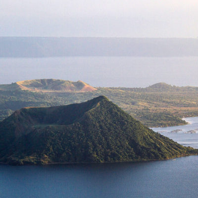


The Taal volcano is particularly popular because the crater is occupied by a lake, logically named Lake Taal. In the middle of this lake is a second crater, forming an island. This island is traditionally known as Volcano Island. In the middle of this island, the crater is also filled with water. And there’s a small rocky island. Just to impress and make things a little fuzzy, this rocky outcrop is often referred to as an island in a lake in an island in a lake in an island. From Tagaytay, a small town close to the volcano, the view is quite impressive, especially when the sky is clear.
Since its first eruption was observed in 1572, Taal has erupted 33 times, all on Volcano Island. The latter has expanded by 25% and the effects have been confined to the caldera, but have sometimes caused damage and loss of life.
Taal Lake is impressive. It covers an area of over 200 square kilometers, and in some places is as deep as 170 meters! Taal Volcano Island is reached by bangka, a traditional Philippine boat. The crossing of Taal Lake takes around 15 to 20 minutes. On arrival, you can hire a horse to make the ascent, but the summit is easily reached on foot in around 45 minutes. The view from the summit is spectacular!