


- Cumulative ascent: 750 meters
- Duration: 3h30
- Low point: Smaltinden Parking (45 m) / High point: Smaltinden (795 m)
- Difficulty: 3/5 / Technique: 2/5
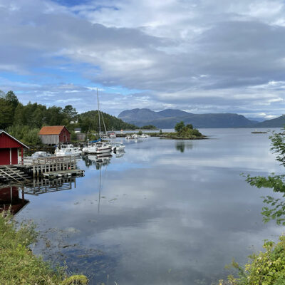
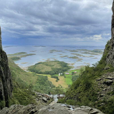
On the edge of the Saltfjellet-Svartisen National Park, the summit of Smaltind stands proudly opposite the Sila Fjord at an altitude of 795 metres. To reach it, a steep and challenging mountain hike awaits, but the trail is well-marked and the terrain easy to navigate. The breathtaking views are almost unbeatable from the first few meters of ascent.
With 750 meters of ascent in just 3.5 kilometers, the hike is indeed steep. However, the ascent is largely gradual. The journey begins with a short stretch on a gravel road before moving on to rocky terrain. The initial few hundred meters take you through a lush birch forest. After that, you’ll be walking mainly on rocky terrain, with a few sections of larger stones nearer the summit. There are several streams along the way, so you can fill up your water bottle. From mid-June onwards, the trail is generally snow-free. We do not recommend this hike in rainy weather, as the stones become very slippery and the terrain dangerous.
The hike to Smaltinden was made on August 18, 2024.
Click on the picture to enlarge it and discover its caption.
We recommend you take along a 1:25000 paper map or a GPX track of this hike. Always be cautious when hiking. Topexpos Voyages and the author of this fact sheet cannot be held responsible for any accident or inconvenience that may occur on this tour.